
Unlock Your Project’s Potential with Advanced Graphic Design and Geographic Information Services
Are you an economic developer, real estate professional, or government agency ready to showcase your vision? We specialize in converting complex aerial map data from sources like NearMap into stunning, functional, and presentation-ready digital assets. We help you make powerful, data-informed decisions.

About Our Expert Team
We are content and digital asset specialists focused largely on the economic development industry, serving both government and private sectors nationwide. We possess the unique resources and technical skill set to handle projects requiring the most complex data transformation and display technologies available today.

Our Comprehensive GIS and Mapping Services
Flyer View Group is your partner in utilizing the full power of location data. We deliver a complete suite of specialized geographic information services designed to elevate every phase of your project, from initial concept visualization to large-scale public displays. We ensure your assets are not only accurate but truly compelling.
Dynamic Map Program
We deliver interactive, always-current GIS assets via a single, permanent online link. This program ensures your audience always views the latest data, including powerful digital terrain model visualizations, without needing new files.

Story Maps
Tell the compelling, chronological narrative of your development or policy initiative. We leverage high-end GIS services to create powerful, web-based story maps that guide audiences through your data with clarity and engagement.

Community Profiles
Elevate your pitch with dynamic, multi-media profiles. We use urban planning and GIS expertise to create engaging digital assets that highlight key demographics, infrastructure, and growth opportunities to attract private investment.

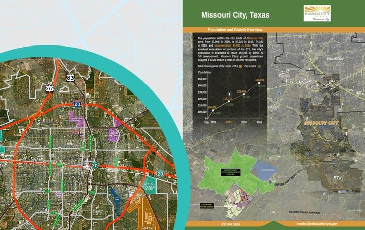
Map Posters & Brochures
For high-impact physical presentations, we design and produce professional map posters and brochures. These printed assets include large-format framed maps and other materials perfect for visitor centers and high-level meetings.

Data-Rich Infographics
We distill vast datasets into clear, powerful visuals. Our geographic information system mapping produces high-impact infographics that simplify complex information, ensuring your most critical data points are immediately understood by any viewer.

Wall Murals
Make a dramatic and permanent statement with a custom aerial map wall mural. We design and install these large-format, permanent displays, perfect for government buildings and corporate lobbies. Designed for you, including options such as gatorboard, acrylic, write-erase lamination and magnetic overlay.
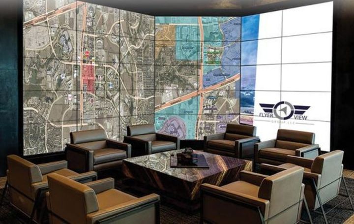
Interactive Experiences
We integrate interactive touch-screen components and custom software to deliver dynamic, high-resolution visual tours and complex data interpretations.

3D Modelling
We transform flat geographic data into realistic, immersive 3D map rendering models. This allows stakeholders to visualize and understand complex development sites, commercial properties, and urban plans with unparalleled clarity and detail.

30 Years of Aerial Imagery Experience
Based in Frisco, TX., Flyer View Group is comprised of 30 years’ experience in Aerial Imagery, Data Research, GIS, Creative Design, and Digital Marketing.
Our enormous wall-size murals and map posters can be found in board rooms and lobbies across the country. The exceptional quality of our data layers and high resolution aerial imagery provide our clients with valuable Project and Community Profile tools to execute major business decisions. The use of information in our aerial maps allows our clients to quickly communicate location, development, land use, proximity to amenities and much more.
We’ve built a reputation of being a client-centric company with unparalleled commitment to the satisfaction of our clients. We’ve become an extremely valuable resource that allows them to greatly improve their likelihood of success and we do not take this responsibility lightly.

Why Choose Us for Your Next Project?
We ensure your vision moves from concept to tangible reality, built on a foundation of accuracy and presentation excellence.
We specialize exclusively in the needs of Economic Developers.
We handle data conversion from complex aerial sources like NearMap.
We offer complete, turn-key solutions from digital rendering to final installation.
Clients That Trust Us


Ready to get started?
Stop presenting flat data and start showcasing a vivid, interactive future. Our expertise turns geographic complexity into clear, conversion-friendly assets. Book a demo today and let us start building your next powerful presentation.